Global Positioning System (GPS) technology underpins nearly every aspect of modern life—from aviation and shipping to banking, agriculture, and daily navigation. Yet this ubiquitous network of satellites faces a persistent threat from outer space: solar storms, particularly coronal mass ejections (CMEs). A powerful CME striking Earth could disrupt or even knock out GPS signals for days or weeks. In such a scenario, an unlikely hero emerges from the past: vintage military celestial navigation techniques that allowed pilots, sailors, and soldiers to find their way using nothing but the stars.
Understanding Coronal Mass Ejections
A coronal mass ejection is a massive burst of solar wind and magnetic fields rising above the Sun's corona or being released into space. When directed toward Earth, these ejections can cause geomagnetic storms that affect our planet's magnetic field. The most infamous historical example is the Carrington Event of 1859, which ignited telegraph wires and caused auroras as far south as the Caribbean. Today, a similar event could devastate the delicate electronics that power GPS satellites.
In 1989, a less powerful CME blacked out the entire Quebec power grid for nine hours. More recently, in 2003, a solar storm knocked out several satellites and caused aircraft to avoid polar routes. The threat is real, and a major CME—classified as an extreme space weather event—could severely degrade or temporarily disable GPS. Since GPS satellites orbit within the Earth's magnetosphere, they are directly exposed to charged particles and radiation spikes. Prolonged exposure can damage solar panels, disrupt onboard computers, and corrupt the precise time signals that GPS relies on.
How GPS Works and Why It's Vulnerable
GPS uses a constellation of about 31 satellites that broadcast timing signals. A receiver calculates its position by measuring the time delay between when a signal was sent and when it arrived. Even a tiny timing error can lead to large navigation mistakes. During a geomagnetic storm, the ionosphere becomes turbulent, causing signal scintillation—rapid fluctuations in amplitude and phase. This makes positions unreliable. Additionally, increased atmospheric drag can cause satellites to drift from their orbits, further degrading accuracy. In worst-case scenarios, satellite electronics can be permanently fried.
The reliance on GPS is so profound that its loss would disrupt not only personal directions but also global supply chains, financial transactions, and emergency response systems. The economic impact could exceed $40 billion per day, according to studies. While backup systems like terrestrial radio beacons exist, they lack global coverage. This is where vintage military navigation techniques come into play.
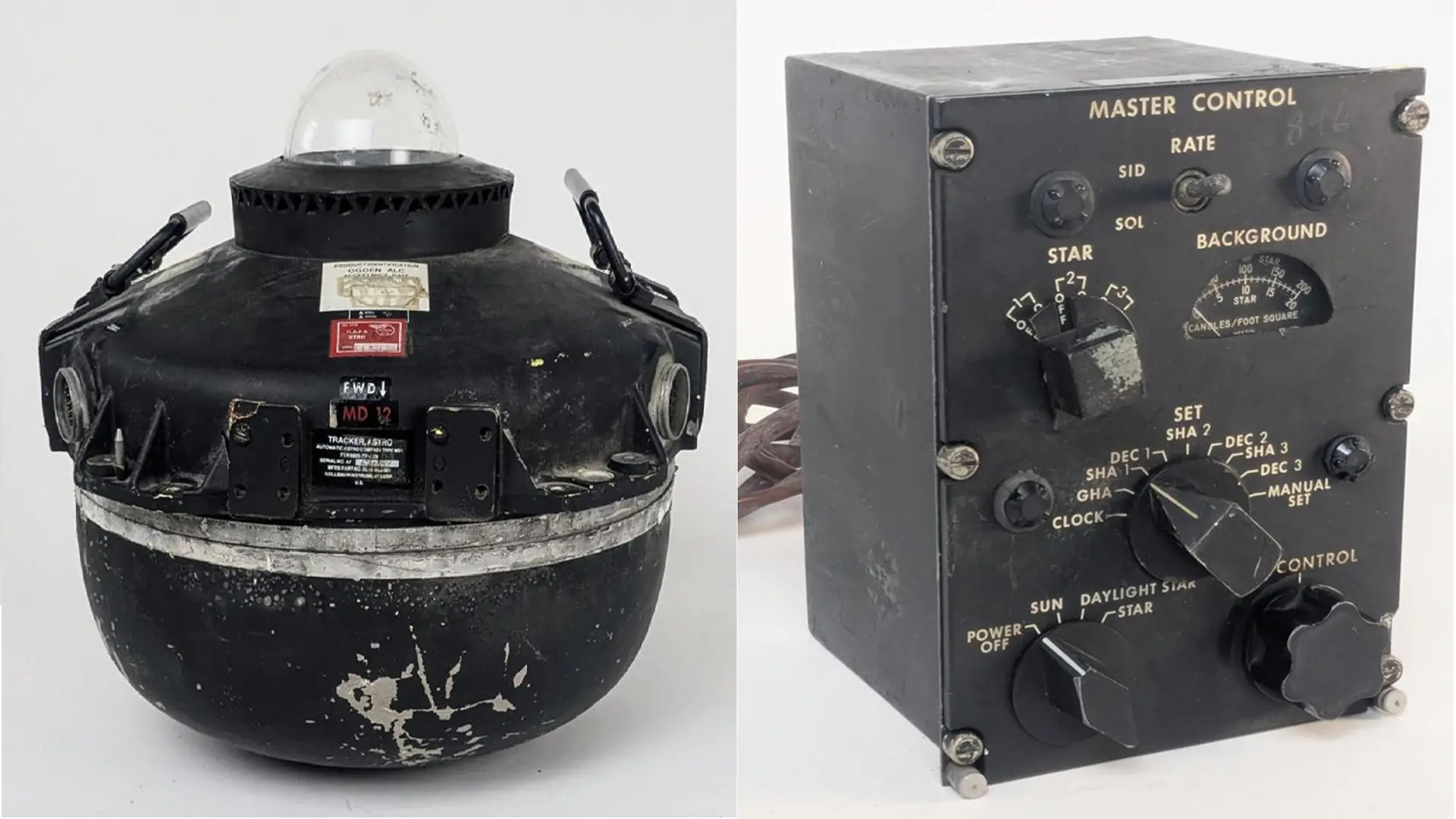
Celestial Navigation: A Timeless Skill
Before GPS, navigation across oceans, deserts, or enemy territory relied on celestial bodies. Using a sextant to measure angles between the horizon and the Sun, Moon, stars, or planets, a navigator could determine their latitude and, with a precise chronometer, their longitude. This method was perfected over centuries and remained at the core of military navigation well into the late 20th century.
The US Air Force, for example, required especially its long-range bomber crews and reconnaissance pilots to be proficient in celestial navigation as late as the 1990s. The B-52 Stratofortress, still in service, originally had a celestial navigation station—the radar navigator could use a hand-held sextant and a periscope sextant to take fixes through a dome on the fuselage. Even modern stealth bombers like the B-2 Spirit include a celestial-inertial navigation system that automatically corrects drift by tracking stars. These systems are hardened against jamming and, crucially, against space weather because they do not rely on satellite signals.
The US Navy also continues to emphasize celestial navigation. Midshipmen at the Naval Academy still learn to use sextants and are tested on star-finding. This tradition persists because the Navy recognizes that GPS can be denied—either by enemy forces or by nature. Submarines, which cannot receive GPS while submerged, have long used celestial periscopes to take sightings. A 2016 article in the US Naval Institute Proceedings argued that the service's gradual move away from celestial training was dangerous, and since then, efforts have been made to revive the skill across the fleet.
Vintage Tech Meets Modern Challenges
While celestial navigation is often romanticized as steam-era relic, it is actually a highly precise mathematical discipline. Modern sextants are not the brass instruments of old; they are lightweight, aircraft-grade aluminum tools with digital readouts. Combined with accurate chronometers (often quartz or atomic timepieces), navigators can obtain position fixes within a few hundred meters—more than adequate for transoceanic flight or shipboard navigation when GPS fails.
Military exercises have tested these skills. In 2017, during the Air Force's Roving Sands exercise in New Mexico, pilots were instructed to navigate using only stars and maps after a simulated GPS outage. They successfully reached targets, demonstrating the value of these venerable techniques. The US Air Force's 86th Airlift Wing trains crews to use sextants, saying it is “like learning a foreign language” but essential for resilience.
Moreover, automated celestial navigation systems are being developed. For example, the Air Force Research Laboratory has experimented with systems that use star trackers (similar to those on spacecraft) to provide heading and position updates for aircraft. These can operate day or night, as long as they can see stars, and are immune to electromagnetic interference. In 2020, a modified C-130 cargo plane successfully flew a four-hour mission using only a celestial navigation system as a backup to GPS.
Why the Stars Will Always Be There
A coronal mass ejection can knock out electronics across a continent, but it cannot block the light from stars. The fundamental geometry of using celestial bodies is as reliable today as it was for Polynesian voyagers or Cold War bombers. While GPS remains the primary navigation tool, a return to basic astro-navigation provides an insurance policy against space weather.
In an era of increasing dependence on fragile space assets, the ability to read the heavens is a skill that must be preserved and taught. As one retired Air Force navigator put it, “The sun can flare up, the solar wind can howl, but the stars are always exactly where they should be. If you know how to ask, they will tell you where you are.”
Source: TechRadar News